Latest updates
Streets from A to Z
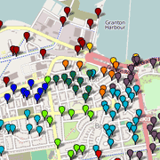
Recently released – a new set of 20 pages, with brief histories of localities and streets in the area north of Ferry Road and from Craighall Road in the east to Silverknowes in the west. Find the street you are interested in from the zoomable interactive map or its dropdown index.
More than 260 streets are detailed, including a few that no longer exist. Also included is a page with suggestions of where to find out more.
These pages will be added to as time allows.
Other recent news
The Chain Pier on YouTube
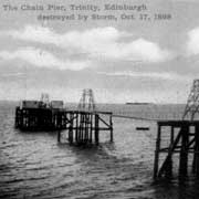
An excellent animation of the Chain Pier in its early days by Jean Hopkins on Youtube. Find out more about the Chain Pier on this website.
And there are more photos...
About this website
This website is run by David King, a local resident with an interest in the history of the area.
Some pages have been researched and written by others, whose contributions I very much appreciate and who are acknowledged on the pages they have contributed.
The website has been re-written from XHTML1.0 into HTML5 and was re-released on 8 October 2012. HTML5 is the latest version of the HyperText Markup Language (the ‘code’ that web pages are written in). Click anywhere in this panel to find out more on Wikipedia.
Shops
New photographs of Gosmans shop at Goldenacre.
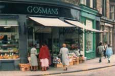
My thanks to Ann Gosman for sending these photographs, and to her and her father for permision to use them.