Civil parish map
To see more detail, move your cursor over the map, and an enlarged rectangle will appear. (This may take a few moments to load.) Use your mouse wheel or equivalent to change the level of magnification.
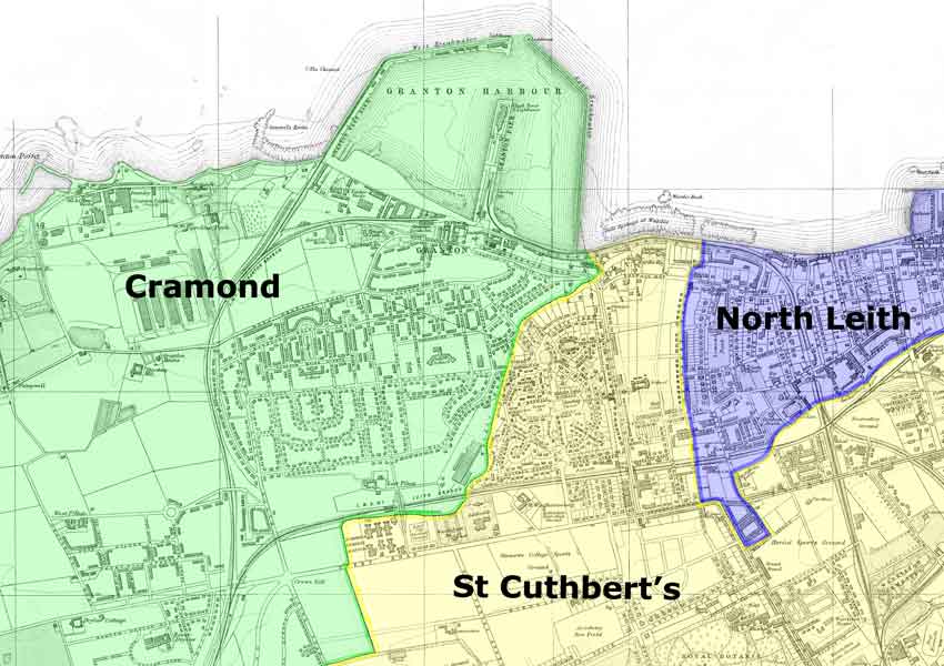
Base map: Bartholomew’s Plan of Edinburgh and Leith, 1940-1941, courtesy of mapseeker.co.uk
Civil parishes
This map shows the three civil parishes that were included in the Granton area. They all extended beyond Granton. The civil parishes were used for a variety of official purposes, including recording births deaths and marriages and for statistical information such as census results. The boundaries were often based on natural features such as rivers and streams, and were established long before many of the present-day streets were laid out.
The civil parishes were the basis for provision of various public services, including – until 1930 – poorhouses. The Granton area was served by poorhouses in North Leith![]() and St Cuthbert’s
and St Cuthbert’s![]() . The poorhouse buildings eventually became the Eastern and Western General Hospitals.
. The poorhouse buildings eventually became the Eastern and Western General Hospitals.
Although the civil parishes were originally based on church parishes, the Church of Scotland later divided them to form additional ‘quoad sacra’ parishes, in other words parishes for church purposes, as new churches were built over the years. During the nineteenth century, the responsibility for assisting the poor and for providing schools passed from the parish churches to new secular authorities.
Further information
For further information, you may wish to visit the National Library of Scotland maps pages using the links below.
Acknowledgement
I am very grateful to Jessie Denholm for her help with this page.
David King, Webmaster