Wardieburn
Introduction
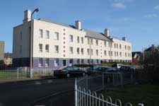
These streets were named after the Wardie Burn, which passed under Ferry Road near the present Morrison’s store, and under Granton Road near the bend before flowing into the Firth of Forth near Wardie Square. It formed the Edinburgh burgh boundary from 1896 to 1900 and can be seen on the boundaries map on this website. The area was developed in the 1930s by Edinburgh Corporation, with some further houses being added more recently on former landscaped areas near road junctions.
The original buildings are understood to have been designed by the City Architect’s Department, the City Architect at the time being E J Macrae.
There was previously a house called Wardieburn House, but it was some distance away, on Ferry Road opposite the present junction with East Fettes Avenue.
Map
Wardieburn Drive
Wardieburn Place East
Wardieburn Place North
Wardieburn Place South
These streets were all named on 1 December 1932.
At the south end of Wardieburn Drive is Granton Parish Church, which has Granton War Memorial in its grounds.
Wardieburn Place West
Wardieburn Road
These streets were both named on 28 December 1933.
Wardieburn Street East
Wardieburn Street West
Wardieburn Terrace
These streets were all named on 1 December 1932.
